Cabin Run Covered Bridge
Coordinates:
(GPS N40’ 25.91” W75’ 06.79”)
(#PA-09-10)
Located on Covered Bridge Road between Stump Road and Dark Hollow Road, near Ralph Stover State Park in Plumstead Twp.
Cabin Run is a Bucks County bridge.
Description:
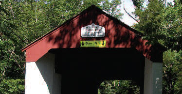
The Cabin Run Covered Bridge crosses Cabin Creek, downstream from the Loux Covered Bridge. Built by David Sutton in 1871, the bridge has a length of 82 ft and is 15 ft wide. It has vertical board siding on the sides, portals and interior walls. The decking is on a diagonal. The sides having no widows, makes it quite dark inside.
The creek’s name was derived from the log cabins and smallstone houses that were built along the creek. During the Revolutionary War, this area was frequented by the Doane Boys notorious Tory outlaws, who lived nearby.
Directions:
From Stump Rd and Wismer Rd, go east onto Stump Rd 0.4 mi. Turn left onto Schletz Hill Rd: 0.7 mi to bridge. Continue onto Covered Bridge Rd 0.2 mi. Note: Stover-Myers Mill County Park and parking are within 0.6 mi on Covered Bridge Road on the otherside of the bridge.