Van Sant Covered Bridge
 Coordinates:
(GPS N40’ 19.59” W74’ 57.46”)
(#PA-09-03)
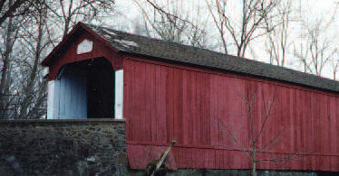
Located in a very rural setting, on Covered Bridge Road, crossing the Pidcock Creek, in Solebury Township.
Van Sant is a Bucks County bridge.
Description:
The Van Sant Covered Bridge is south of New Hope near Washington’s Crossing Historical Park. It was built in 1875 by G. Arndt and P. S. Naylor. They used the Town Truss construction. The bridge is 86 ft long and 15 ft wide and has one span. A hallmark of Bucks County bridges, it is red with white entry portals.
Directions:
From Rt. 32 (River Rd) (just north of the Thomas Neeley House) go west onto Aquetong Rd 0.4 mi. Turn left onto Covered Bridge Rd go 1.0 mi to bridge. Note: Covered Bridge Rd becomes Van Sant Rd on the other side of the bridge.