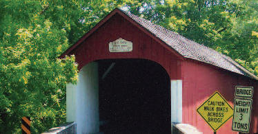
Knecht’s Covered Bridge
 Coordinates:
(GPS N40’ 32.29” W75’ 16.67”)
(#PA-09-02)
Knecht’s bridge (also known as Slifer’s Bridge) is located just off Slifer Valley Rd on Knecht’s Rd in Springfield Township, south of Springtown.
Knecht’s is a Bucks County bridge.
Description:
Crossing Cooks (Durham) Creek, the Knecht’s Covered Bridge was built of hemlock in 1873 and usesthe Town Truss with one span. The 110 – ft by 15 – ft bridge is painted the traditional red with white entry portals. Slifer Valley was named for the early German settlers who resided here prior to 1750. Their descendants is still farmed the area. Be sure to look for the Slifer log cabin, sitting just off Slifer Valley Road near the bridge. This bucolic area is dotted with stone Bucks County farm houses. Nearby is the route of history’s “Walking Purchase” of 1737.
Directions:
From Rt. 412 and Slifer Valley Rd, go west on Slifer Valley Rd 1.8 mi, and the bridge is on the left.

